HAPPY LANDING. The red oval in this THEMIS nighttime infrared mosaic marks the landing site ellipse for Phoenix. Lighter shades of gray indicate warmer and rockier ground. (Click on the image to download a larger version.)
credit: NASA/JPL/Arizona State University
ASU's Thermal Emission Imaging System helped scientists find a safe landing site for the Mars Phoenix spacecraft - and the instrument is also giving flight controllers essential data on the atmosphere to ensure a safe touchdown.
On Sunday, May 25, 2008, the Phoenix spacecraft (a joint project between NASA and the University of Arizona) will arrive at Mars after a 10-month cruise from Earth. Traveling initially at 12,500 miles per hour (5.7 kilometers per second), Phoenix will make a hair-raising, nail-biting, 6-and-a-half-minute plunge though the Martian atmosphere to a smooth landing on icy dirt not far from the edge of the Red Planet's northern polar cap.
This is territory where no spacecraft has successfully landed. On Earth, the landing site (latitude 68 degrees north, longitude 233 degrees east) would lie not far from the town of Inuvik in Canada's Arctic. On Mars, the site, dubbed "Green Valley," lies on the rolling northern plains. It features water ice at depths of a few inches or centimeters; this ice is the spacecraft's target. The goal of the Phoenix mission is to scrape up some of the icy dirt and analyze it to determine its habitability for microorganisms.
The chosen landing area appears smooth, flat, and what's most important, relatively free of rocks and boulders. The site's suitability was established in part through surveys by ASU's Thermal Emission Imaging System (THEMIS), a visible and infrared camera on NASA's Mars Odyssey orbiter.
In addition, THEMIS is also providing mission controllers with data on the dustiness of the Martian atmosphere. This will help them decide when to open the parachutes and fire the retro-rockets to guide Phoenix to a safe landing.
Seeking safe harbor
"THEMIS' main contribution to Phoenix was identifying places where it's safe to land," says Philip Christensen, of Arizona State University's Mars Space Flight Facility in the School of Earth and Space Exploration. A Regents' Professor of Geological Sciences in the College of Liberal Arts and Sciences, Christensen designed THEMIS and is the instrument's principal investigator.

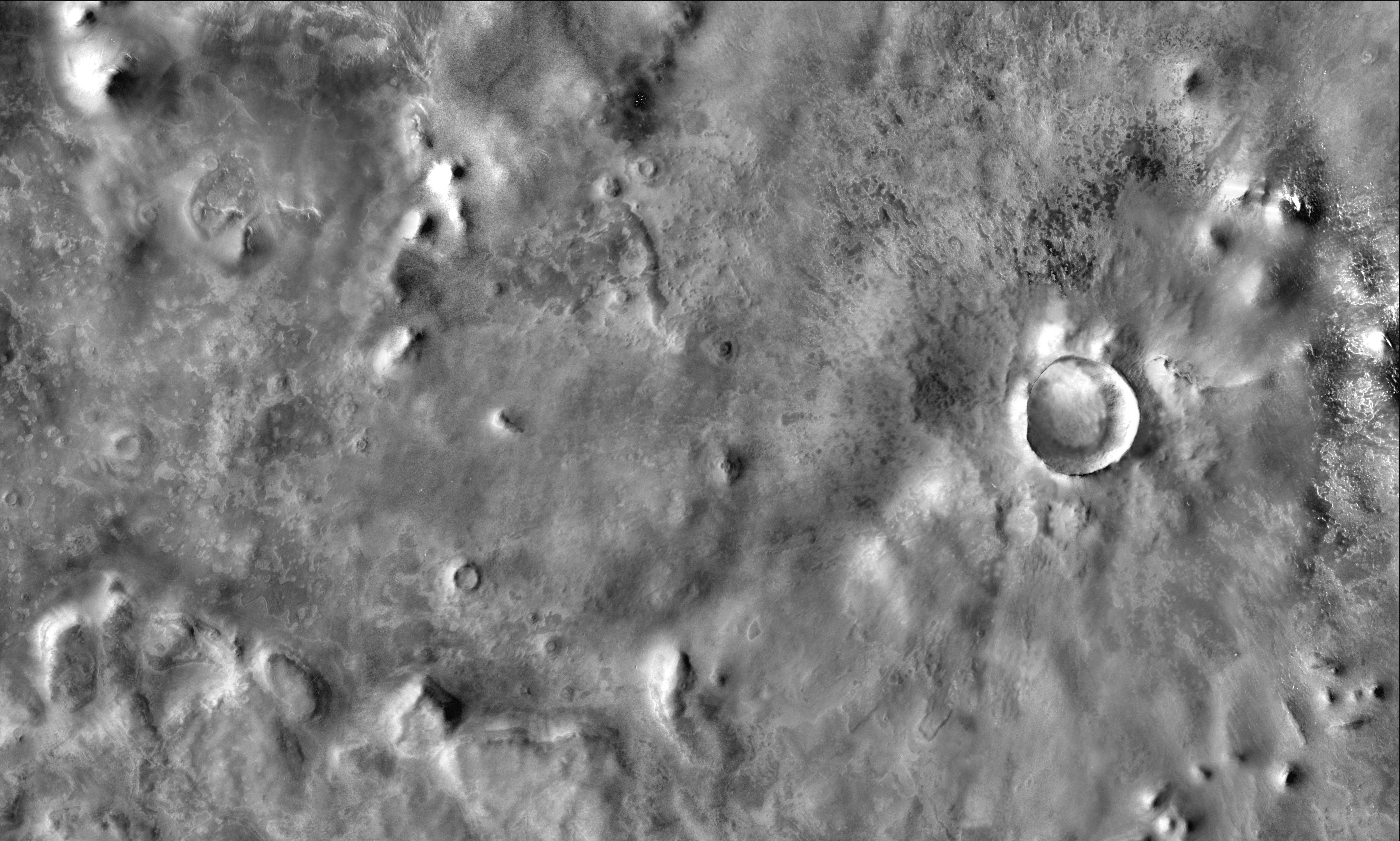
SAFE HARBOR? The landing ellipse for Phoenix lies in what looks like a smooth, relatively rock-free area, as seen in this THEMIS mosaic made in daytime visible light. (Click on the image to download a 4 megabyte version with no annotation.)
credit: NASA/JPL/Arizona State University
The Phoenix science team chose to land within a latitude band centered on 70 degrees north. Then, says Greg Mehall, mission manager for the Mars Space Flight Facility, "We collected temperature and imaging data sets over that entire band, all around the planet, for the last several years."
Christensen says the THEMIS team studied the region's geology. "We were using the THEMIS data to get a sense of the rock abundance," he says. "Rocks stay warmer at night, so by looking at nighttime infrared temperature data we were able to see warm, rocky areas Phoenix should avoid."
Christensen continues, "We saw a lot of these warm patches, so I raised a small caution. The intended landing areas were looking a good bit rougher than the Gusev and Meridiani landing sites where the Mars Exploration Rovers Spirit and Opportunity had landed."
Then the HiRISE camera on NASA's Mars Reconnaissance Orbiter imaged one of the THEMIS warm areas. "They found these incredible boulder fields," Christensen says. "Half the ground was covered with rocks the size of a kitchen table or bigger."
He continues, "That prompted us to systematically compare HiRISE images to the THEMIS nighttime temperatures. And we found a beautiful correlation between the warm patches and the places with lots of rocks."
Why couldn't the Phoenix team simply use detailed images from HiRISE to pick a site? As Christensen explains, "HiRISE takes very detailed images, but they cover only tiny areas. So there was no hope of imaging all the candidate sites in time."
With a wider field of view, however, THEMIS had little difficulty surveying the entire area, mapping its nighttime temperatures. "What we did," says Christensen, "was take all the THEMIS data, make mosaics of night infrared images, and look for places that were the coldest."
The scientists figured the coldest places probably had the fewest rocks, and those would make good places to start hunting for possible landing sites.
"Using the THEMIS data, we picked a couple of places where you could squeeze in the Phoenix landing ellipse," notes Christensen. "We selected the landing sites, and then HiRISE subsequently imaged those sites and confirmed they indeed have no rocks."
"Together, THEMIS and HiRISE made a great team," he says.
Something in the air
Besides landing site selection, THEMIS is also helping mission controllers get Phoenix down safely by monitoring the Martian atmosphere. To plan the entry, descent, and landing stages for Phoenix, mission engineers need to know the winds, density, and temperatures of the atmosphere at all altitudes from space down to the ground.
"For the past two months, we've been using THEMIS to watch intensively for dust in the atmosphere," says Mehall. "The Phoenix landing team is using a web page we created for them that has constantly updated dust-opacity maps."

CLEARING THE AIR. The great dust storm that erupted in June 2007 slowly faded as months passed. This 30-second video, made from THEMIS data, shows the amount of atmospheric dust by color: the redder the area, the dustier the atmosphere. Skies over the Phoenix landing site should be clear.
Video downloads: credit: NASA/JPL/Arizona State University
A huge global dust storm arose in June 2007, and that kicked atmospheric observations into high gear, says Kim Murray, data archivist at the Mars Space Flight Facility. "THEMIS couldn't see the surface."
THEMIS was designed primarily as a geological instrument, but every image captures atmosphere as well, Murray notes. "We're taking infrared images that record both the surface and whatever is in the atmosphere above the ground," she says. "All of that is in the image."
Since THEMIS began operations in early 2002, Murray explains, scientists have built up a "clear skies" model for the surface. "This allows us to subtract the surface component from the total in an image, and that leaves the atmospheric part," she explains. "The atmospheric component then gets further analyzed to extract the contributions from dust and ice. We also determine what altitude these are at."
After 2007's big dust storm, activity has died down, and in recent months, the atmosphere has become a lot quieter and much more transparent. (See video.)
Says Murray, "For the last month, our main support role for the entry, descent, and landing phase has been the infrared atmosphere campaign."
It's a role the Mars Space Flight Facility has played before, beginning with the Thermal Emission Spectrometer (TES). This was an infrared-sensing instrument on NASA's Mars Global Surveyor orbiter, which operated from 1996 to 2006. While TES' main mission was mapping the mineralogy of Mars, its wavelength sensitivity let scientists use it to probe the atmosphere as well.
"Our atmospheric knowledge really began with TES," says Murray. "Most recently, from March to November 2006, THEMIS helped the Mars Reconnaissance Orbiter team with its aerobraking maneuver when the spacecraft first arrived at Mars. At the time, we were lucky to have both TES and THEMIS working. That helped us build up our knowledge of the atmosphere a lot."
Says Christensen, "The good news for Phoenix is that they are landing in the northern spring, which is about the clearest time of year for the atmosphere. We wish them the best of luck and a smooth landing."
 e image. The neighbouring Tr16-244 is the third brightest, just to the upper left of WR 25. The second brightest, to the left of WR 25, is a low mass star located much closer to the Earth than the Carina Nebula. Stars like WR 25 and Tr16-244 are relatively rare compared to other, cooler types. They interest astronomers because they are associated with star-forming nebulae, and influence the structure and evolution of galaxies.
 e La Serena in Chile, discovered that it is composed of at least two stars. The more massive is a Wolf-Rayet star and may weigh more than 50 times the mass of our Sun. It is losing mass rapidly through powerful stellar winds that have expelled the majority of its outermost hydrogen-rich layers, while its more mundane binary companion is probably about half as massive as the Wolf-Rayet star, and orbits around it once every 208 days.
  discover the properties of massive stars.